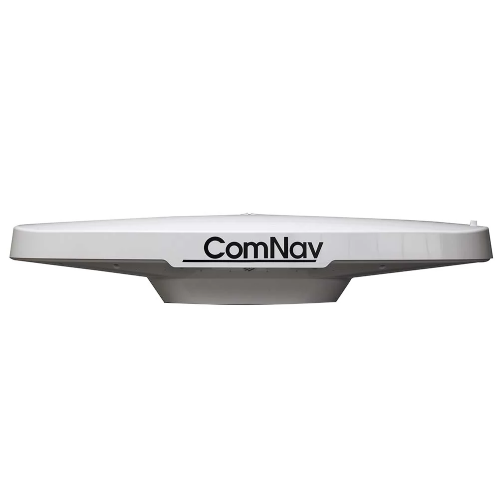
ComNav G2 GNSS Satellite Compass, NMEA 0183, w/30m cable - 11220002
ComNav G2 GNSS Satellite Compass, NMEA 0183, w/30m cable - 11220002
The Vector G2ComNav G2 GNSS GPS Compass is a state-of-the-art electronic navigation data device. It is capable of providing highly accurate, high-precision position and heading data to a wide variety of marine Navigation equipment, such as autopilots, sonar, radar, chartplotters, AIS receivers & transponders, and many other types of marine devices & systems. The ComNav G2 GNSS features fast start-up and signal re-acquisition times, heading & position updates at up to 20 times per second, and can operate at sustained turn rates up to 90° per second. The ComNav G2 GNSS is a complete GPS Compass in a single rugged, marine-grade enclosure. It needs only one single power/data cable, which greatly simplifies installation.
- New: Supports both GPS and GLONASS satellites for complete redundancy
- New: Heading accuracy < 0.25° rmsSatellite Compass
- New: Position accuracy < 0.3m 95% confidence (DGPS)
- New: An integrated 9 Axis Inertial Measurement Core (IMC technology) provides enhanced roll, tilt and heading stability even during momentary loss of satellite signals
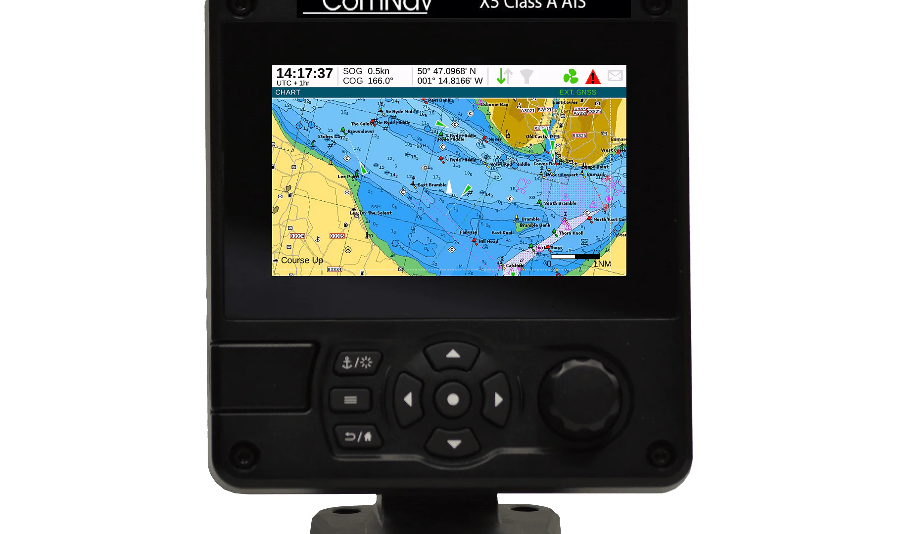
- New: IMO Compliant G3 color display system (optional)
- New: Engineered enhancements to exceed sealed IP67 rating
- New: Extended 2 year warranty • NMEA 0183 and NMEA 2000® interface
- Type approved as primary heading AND positioning device
- Heave, Pitch, Roll and Rate of Turn as standard output
- Heading updates 1 to 20 Hz
- BAUD Rate selectable: 4800, 9600, 19200, 38400,115200
- Fully compatible with on board NMEA 0183 and NMEA 2000® RADAR, ECDIS, AIS, Cameras, SONAR, PC and Autopilots
- Compact integrated surface mounting (Pole mount optional)
- IMO Compliant, Wheelmark and USCG approved
- Pre-programmed default settings for Heading, Rate of Turn, Course over Ground, Lat/Long position, Time & Date
- 1PPS output standard
- 15 meter serial cable standard (30 meter optional)
- 6 meter NMEA 2000® Cable (Optional)
- CE certified for EMI and RFI immunity
- Worldwide service
There are two models available – the ComNav G2 GNSS Satellite Compass and the ComNav G2B GNSS Satellite Compass. They are identical, except in their Differential GPS (DGPS) correction features:
- The G2 can obtain DGPS information from many Space-Based Augmentation System (SBAS) sources (in areas where compatible ones are available & operational), including WAAS, EGNOS, MSAS, SNAS, GAGAN and others. The G2 can also accept DGPS information from an external data source.
- The G2B has an additional integrated beacon receiver module, which allows it to use conventional terrestrial DGPS Radiobeacon signals to obtain DGPS information, in addition to SBAS sources & external DGPS data sources.
The G2 GPS Satellite Compass supports multiple RF front ends - enabling tighter coupling of measurements from separate antennas for use in heading-based products. Users will achieve excellent accuracy and stability due to the more accurate code phase measurements, improved multi path mitigation, and fewer components.
The G2/B’s GPS antennas are separated by 50 cm between their phase centers, resulting in 0.5° rms heading performance. The G2/B provides heading and positioning updates of up to 20 Hz and delivers positioning accuracy of 1.0 m 95% of the time when using differential GPS corrections from beacon (G2B only) or from Space Based Augmentation Systems (SBAS).
The G2/B also features technology that enables ComNav GPS Satellite receivers to utilize old differential GPS correction data for 40 minutes or more without significantly affecting the positioning quality. The G2/B is less likely to be affected by differential signal outages due to signal blockages, weak signals, or interference.
GPS Sensor Specifications
- Receiver Type: L1, C/A code, with carrier phase smoothing
- Channels: Two x 32 parallel tracking GPS, GLONASS, SBAS
- Update Rate: Standard 10 Hz, Selectable up to 20 Hz (position and heading)
- Horizontal Accuracy: < 0.3 m 95% confidence (DGPS)* < 2.5 m 95% confidence (autonomous, no SA)**
- Heading Accuracy: < 0.25º rms
- Pitch / Roll Accuracy: < 1º rms
- Rate of Turn: 90º / sec max
- Start-up Time: < 60 sec typical
- Heading Fix: < 10 sec
- Satellite Reacquisition: < 1 sec
- Timing Output: 1PPS, 50 ns accuracy, CMOS
Beacon Receiver Specifications (G2B)
- Channels: 2-channel, parallel tracking
- Frequency Range: 283.5 to 325 kHz
- Operating Modes: Automatic (signal strength or range) and manual
- Compliance: IEC 61108-4 beacon standard
Communications
- Serial Ports: 1 full-duplex RS-232 and 1 full-duplex RS-422
- Baud Rates: 4800 - 115200
- Correction I/O Protocol: RTCM v2.3 (DGPS), RTCM SC-104
- Data I/O Protocol: NMEA 0183 / Optional NMEA 2000® / Proprietary ASCII
- Heading Warning I/O: Open relay system indicates invalid heading
- NMEA Heading Messages: $GPHDT, $GPROT, $PSAT, $GPHDM, $GPHDG
- Timing Output: 1PPS CMOS, active low, 10KΩ, 10pF load
Environmental
- Operating Temperature: -32ºC to +74ºC (-25ºF to + 165ºF)
- Storage Temperature: -40ºC to +85ºC (-40ºF to + 185ºF)
- Humidity: 0 - 99% non-condensing
Power
- Input Voltage: 10 to 36 VDC
- Power Consumption: ~ 3 W nominal
- Current Consumption: ~ 250 mA @ 12 VDC
- Isolation: Power supply isolated from serial ports
- Reverse Polarity Protection: Yes
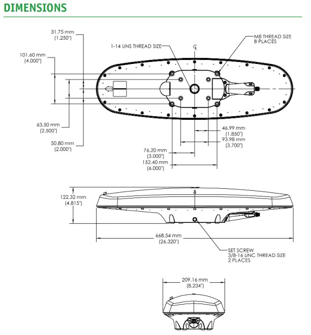
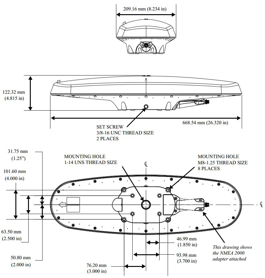
Mechanical
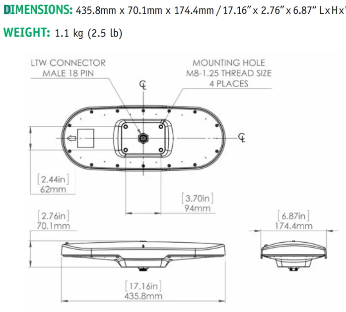
- Dimensions: (see figure)
- Weight: G2: 2.2 kg (4.8 lb) / G2B: 2.7 kg (5.9 lb)
- Power/Data Connection: 18-pin, Environmentally sealed IP67 sealed
- 15m or 30m cable (options)
Aiding Devices
Gyro: Provides smooth heading, fast heading reacquision and reliable < 1º heading for periods up to 3 minutes when loss of GPS has occured (static conditions)
Tilt Sensor: Assists in fast start up of heading solutions
* Depends on multipath environment, number of satellites in view, satellite geometry, baseline length (for local services),
and ionospheric activity.
** Depends on multipath environment, number of satellites in view, and satellite geometry
Additional Options:
- 6m NMEA 2000® Cable (not IMO compliant)
- Color LCD Sunlight G3 Instrument Display
This product is the next generation replacement for ComNav Model 11210002, which is no longer available.
Product Information
Product Information
Shipping & Returns
Shipping & Returns
Description
ComNav G2 GNSS Satellite Compass, NMEA 0183, w/30m cable - 11220002
The Vector G2ComNav G2 GNSS GPS Compass is a state-of-the-art electronic navigation data device. It is capable of providing highly accurate, high-precision position and heading data to a wide variety of marine Navigation equipment, such as autopilots, sonar, radar, chartplotters, AIS receivers & transponders, and many other types of marine devices & systems. The ComNav G2 GNSS features fast start-up and signal re-acquisition times, heading & position updates at up to 20 times per second, and can operate at sustained turn rates up to 90° per second. The ComNav G2 GNSS is a complete GPS Compass in a single rugged, marine-grade enclosure. It needs only one single power/data cable, which greatly simplifies installation.
- New: Supports both GPS and GLONASS satellites for complete redundancy
- New: Heading accuracy < 0.25° rmsSatellite Compass
- New: Position accuracy < 0.3m 95% confidence (DGPS)
- New: An integrated 9 Axis Inertial Measurement Core (IMC technology) provides enhanced roll, tilt and heading stability even during momentary loss of satellite signals
- New: IMO Compliant G3 color display system (optional)
- New: Engineered enhancements to exceed sealed IP67 rating
- New: Extended 2 year warranty • NMEA 0183 and NMEA 2000® interface
- Type approved as primary heading AND positioning device
- Heave, Pitch, Roll and Rate of Turn as standard output
- Heading updates 1 to 20 Hz
- BAUD Rate selectable: 4800, 9600, 19200, 38400,115200
- Fully compatible with on board NMEA 0183 and NMEA 2000® RADAR, ECDIS, AIS, Cameras, SONAR, PC and Autopilots
- Compact integrated surface mounting (Pole mount optional)
- IMO Compliant, Wheelmark and USCG approved
- Pre-programmed default settings for Heading, Rate of Turn, Course over Ground, Lat/Long position, Time & Date
- 1PPS output standard
- 15 meter serial cable standard (30 meter optional)
- 6 meter NMEA 2000® Cable (Optional)
- CE certified for EMI and RFI immunity
- Worldwide service
There are two models available – the ComNav G2 GNSS Satellite Compass and the ComNav G2B GNSS Satellite Compass. They are identical, except in their Differential GPS (DGPS) correction features:
- The G2 can obtain DGPS information from many Space-Based Augmentation System (SBAS) sources (in areas where compatible ones are available & operational), including WAAS, EGNOS, MSAS, SNAS, GAGAN and others. The G2 can also accept DGPS information from an external data source.
- The G2B has an additional integrated beacon receiver module, which allows it to use conventional terrestrial DGPS Radiobeacon signals to obtain DGPS information, in addition to SBAS sources & external DGPS data sources.
The G2 GPS Satellite Compass supports multiple RF front ends - enabling tighter coupling of measurements from separate antennas for use in heading-based products. Users will achieve excellent accuracy and stability due to the more accurate code phase measurements, improved multi path mitigation, and fewer components.
The G2/B’s GPS antennas are separated by 50 cm between their phase centers, resulting in 0.5° rms heading performance. The G2/B provides heading and positioning updates of up to 20 Hz and delivers positioning accuracy of 1.0 m 95% of the time when using differential GPS corrections from beacon (G2B only) or from Space Based Augmentation Systems (SBAS).
The G2/B also features technology that enables ComNav GPS Satellite receivers to utilize old differential GPS correction data for 40 minutes or more without significantly affecting the positioning quality. The G2/B is less likely to be affected by differential signal outages due to signal blockages, weak signals, or interference.
GPS Sensor Specifications
- Receiver Type: L1, C/A code, with carrier phase smoothing
- Channels: Two x 32 parallel tracking GPS, GLONASS, SBAS
- Update Rate: Standard 10 Hz, Selectable up to 20 Hz (position and heading)
- Horizontal Accuracy: < 0.3 m 95% confidence (DGPS)* < 2.5 m 95% confidence (autonomous, no SA)**
- Heading Accuracy: < 0.25º rms
- Pitch / Roll Accuracy: < 1º rms
- Rate of Turn: 90º / sec max
- Start-up Time: < 60 sec typical
- Heading Fix: < 10 sec
- Satellite Reacquisition: < 1 sec
- Timing Output: 1PPS, 50 ns accuracy, CMOS
Beacon Receiver Specifications (G2B)
- Channels: 2-channel, parallel tracking
- Frequency Range: 283.5 to 325 kHz
- Operating Modes: Automatic (signal strength or range) and manual
- Compliance: IEC 61108-4 beacon standard
Communications
- Serial Ports: 1 full-duplex RS-232 and 1 full-duplex RS-422
- Baud Rates: 4800 - 115200
- Correction I/O Protocol: RTCM v2.3 (DGPS), RTCM SC-104
- Data I/O Protocol: NMEA 0183 / Optional NMEA 2000® / Proprietary ASCII
- Heading Warning I/O: Open relay system indicates invalid heading
- NMEA Heading Messages: $GPHDT, $GPROT, $PSAT, $GPHDM, $GPHDG
- Timing Output: 1PPS CMOS, active low, 10KΩ, 10pF load
Environmental
- Operating Temperature: -32ºC to +74ºC (-25ºF to + 165ºF)
- Storage Temperature: -40ºC to +85ºC (-40ºF to + 185ºF)
- Humidity: 0 - 99% non-condensing
Power
- Input Voltage: 10 to 36 VDC
- Power Consumption: ~ 3 W nominal
- Current Consumption: ~ 250 mA @ 12 VDC
- Isolation: Power supply isolated from serial ports
- Reverse Polarity Protection: Yes
Mechanical
- Dimensions: (see figure)
- Weight: G2: 2.2 kg (4.8 lb) / G2B: 2.7 kg (5.9 lb)
- Power/Data Connection: 18-pin, Environmentally sealed IP67 sealed
- 15m or 30m cable (options)
Aiding Devices
Gyro: Provides smooth heading, fast heading reacquision and reliable < 1º heading for periods up to 3 minutes when loss of GPS has occured (static conditions)
Tilt Sensor: Assists in fast start up of heading solutions
* Depends on multipath environment, number of satellites in view, satellite geometry, baseline length (for local services),
and ionospheric activity.
** Depends on multipath environment, number of satellites in view, and satellite geometry
Additional Options:
- 6m NMEA 2000® Cable (not IMO compliant)
- Color LCD Sunlight G3 Instrument Display
This product is the next generation replacement for ComNav Model 11210002, which is no longer available.